Category Archives: Hiking

Westmorland Park

Westmorland Park shelter on December 31, 2021

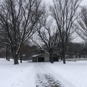
Westmorland Park on December 31, 2021

Westmorland Park is another City of Madison park. The official address is 4114 Tokay Boulevard, which is four or five blocks east of Midvale Boulevard. It’s a relatively small park, bounded by Tokay Boulevard, Gately Terrace, Park Lane and St. Clair Street.

While it is a small park, there are basketball and tennis courts, some walking paths, both paved and unpaved, and a very nice shelter. In the winter there is a skating rink and there are some small hills that are suitable for sledding.

I enjoy walking in the Westmorland Park neighborhood a lot; the parkj is very nice but kind of small, but the neighborhood is just a nice place for a walk. Here is a map of one of my recent walks:

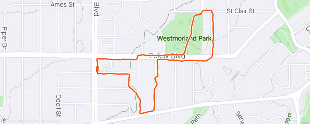
Walking route near Westmorland Park on 2021-12-31.

I usually park near Midvale Community Lutheran Church and then I walk down Wakefield Street to Leeds Street, and from there I take one of the walkways to Chatham Terrace. On this walk I took the walkway towards Odana Road. From Odana Road, I walked down to Anthony Lane and from there to Tokay Boulevard. Then I just followed Tokay to Park Lane, passing Westmorland Park on my left.

Just before crossing the street to walk up Park Lane, Tillotson Park is on the right. It’s really more of a neighborhood green space than a true park, but there is a path that leads to the Southwest Commuter bike path.

After walking up Park Lane and turning left onto St. Clair Street, the park is just on the left. There’s a nice paved path that leads through the park, past the shelter and ends at Tokay Boulevard. From here I just walk back along Tokay to where I parked the car.

Stricker’s Pond

Stricker's Pond on November 6, 2020

Stricker’s Pond on November 6, 2020

Stricker’s Pond straddles the border between the cities of Madison and Middleton. It is one of the kettle ponds in Middleton and on the west side of Madison that were formed during the last Ice Age. I’m not really sure how long it has been a park or conservancy in either of the two cities.

The official address of the Madison park is 7214 Longmeadow Road, and the neighborhood park in Middleton is at 7605 Voss Parkway.

The pond has really suffered over the years, with so much development around it, a lot of water runs off and int the pond. This has caused some flooding issues during major rainfall events, like we had in August 2018. Also, invasive species have causes problems in the conservancy, though volunteers are working to remove invasive plants. Unfortunately, there will be no easy way to get rid of the goldfish which inhabit the pond itself!

Here is my usual walk around the pond:

Route map of Stricker's Pond

Walking route at Stricker’s Pond on 2020-11-06

I typically park along Longmeadow Road and proceed around the pond clockwise. The path from the road to Stricker Park on the northwest side of the pond is not paved. It’s basically a dirt path although some sections are gravel. At Stricker Park there is a (mostly) paved path that loops around the park area. Along the north side of the pond is wide a gravel path that connects with Middleton Street on the east side of the park. From there I typically walk on the street until I reach the dead end, and then I take the paved path back to the start. It’s about 1.1 miles all together, though doing the full loop around Stricker Park would add to the mileage.

Lakeview Park

Lakeview Park in Middleton is located on Allen Boulevard and Mendota Avenue. It is the largest park in the City of Middleton and has facilities for baseball, tennis and disc golf. It also has a splash pad that is open in the summer, along with play equipment. A Veterans Memorial has been added on the Allen Boulevard side of the par in the last few years.

The parking lots are accessible from the Mendota Avenue side of the park; the main parking lot is at the intersection with N Gateway Street. This is the parking area that is most convenient for the park shelter and tennis courts. The shelter house was completely remodeled in 2020.

There are a number of paths in the park and almost all of them are paved.

Route Map in Lakeview Park

Walking Route in Lakeview Park on 2020-11-09

I typically start my walk at the new parking lot near the corner of Allen Boulevard and Mendota Avenue. I walk on the path along Allen Boulevard and then follow the path towards the pond, past the baseball complex and the second small pond to the disc gold area. The path then heads past Sauk Trail School up to Branch Street. I follow Branch Street to Mendota Ave. Sometimes I walk straight down Mendota Avenue to the parking lot, but occasionally I walk over to Lakeview Boulevard before returning to the parking area.

Garner Park

Garner Park on May 10, 2020

Garner Park on May 10, 2020

Garner Park is one of the City of Madison’s parks. It’s officially located at 333 S. Rosa Road. The park is bounded by Rosa Road, South Hill Drive, Whitney Way and Mineral Point Road. The park was created in 1965 or so, but the distinctive shelter house was not completed until 1976.

The parking lot is located off of Rosa Road near the intersection with Mineral Point Road.

The park is home to the annual Opera in the Park, which is hosted by the Madison Opera.

I enjoy walking on the paths at Garner Park. Most of the paths are paved, though there are a few that are just grass. Here is a map of one of my typical walks:

Route Map in Garner Park

Walking route in Garner Park on 2020-11-18

I typically walk past the shelter  and the tennis courts towards South Hill Drive and then walk over to Rosa Road and then take the path below the shelter back toward the tennis courts. There are some basketball courts just off of Rosa Road (across from Driftwood Avenue) where the path across the open field begins. This is typically where most people enter the park for Opera in the Park.

Sunset Hike at Devil’s Lake 2013-06-14

On Friday June 14th, Kimiko and I went to Devil’s Lake after I finished work. We stopped at my house so I could change clothes and also remove the snow shovel from the trunk of my car: this is how I traditionally celebrate Flag Day. And then we were off to Baraboo.

As always, we parked in the South Shore area of Devil’s Lake State Park. We started on the Balanced Rock trail – it’s good to get the steep part out of the way first! There were a lot of folks out on the lake – fishing and canoeing and even some paddle boards. The climb on the trail isn’t too bad and there are a couple of good places to stop and enjoy the view on the way up.

Once we got to the top, we headed off on the East Bluff trail, heading towards the North Shore area. At a certain point we began to hear music apparently coming from the lodge or cabin or whatever at the North Shore. It turns out that they have live music on Friday nights as well as a catered fish fry.

Kimiko had made a picnic lunch and we stopped near the beach to eat and take a break. Overhead we noticed a fairly large number of hawks circling around. They were obviously riding the thermal air currents but I was pretty amazed at the large number of birds.

After we ate, we headed back along the west side of the lake on the Tumbled Rocks trail. It was good to get moving again – the breeze off the lake felt a little too cool while we stopped to eat. We walked along the highway to the South Shore area as the sun began to set. It was a beautiful sunset.